
March 1st Water Supply Outlook Report for Utah
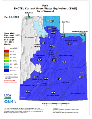
The snow keeps coming! We are now roughly one month from when Utah’s snowpack typically peaks, and our conditions remain outstanding. Statewide, the snow water equivalent (SWE) measured at our SNOTEL sites was 161% of normal as of March 1st, with all major basins except the Raft above 140%. Utah surpassed its typical peak snowpack on January 18th, and the snow just keeps piling up! Statewide SWE projections suggest that Utah’s snowpack may be as high as 150% of our typical peak by the end of the month. What a winter! Our statewide SWE continues to compare with some of our best snowpack seasons on record, including 1984, 2005, and 2011.
As noted in last month’s report, new records for snow water equivalent are being set at Utah’s SNOTEL sites. As of March 1st, 10 sites were reporting a record high amount of SWE compared with the last 30 years, and 7 more were second highest. The Vernon Creek SNOTEL at the south end of the Tooele watershed already has 231% of its typical peak snowpack! Four other SNOTEL sites also have around double the amount of snow that they would have at their typical peak. The vast majority of Utah’s 137 SNOTEL sites are at (or above) the 85th percentile for SWE compared to their period of record, with 31 in the top five percent.
February precipitation in Utah was above normal at 123%, bringing the water-year-to-date precipitation to 139% of normal. All of Utah’s major watersheds remain above 115% of normal precipitation for the 2023 water year. Statewide soil moisture is above normal at 56% of saturation, which bodes well for our snowmelt runoff efficiency. Utah’s reservoir storage is currently at 51% of capacity, down 2% from this time last year. While many small to medium-size reservoirs will fill, some of Utah’s largest (e.g. Sevier Bridge Reservoir and Bear Lake) most likely will not, and of course the water levels in both Lake Powell and the Great Salt Lake remain critically low. Utahns will need to continue to conserve water to help make progress replenishing our storage systems.
As noted last month, NRCS streamflow forecasts for April to July snowmelt runoff volume are based mainly on observed SWE and precipitation at Utah’s SNOTEL sites. March 1 forecasts are very high, with >200% of normal flow forecast for many locations. As we round the corner on winter and head towards early spring, our confidence in these water supply forecasts increases. There continues to be excellent agreement between our forecasts and those provided by the Colorado Basin River Forecast Center (NOAA). Overlap in CBRFC and NRCS forecasts lends confidence considering the different methodological approaches used. Both can be viewed on the new Forecast Comparison page which is intended to be a one-stop landing page for water managers to find snowmelt runoff forecasts from both agencies for any location in Utah and compare the values.
Surface Water Supply Indices (SWSI) for Utah basins combine our current reservoir levels with the additional volume of water anticipated for each watershed based on these March 1 streamflow forecasts. Some areas of the state with significant ground to make up (due to large amounts of depleted reservoir storage) continue to have low SWSI values, such as the Provo basin. Other areas have much higher SWSI values, such as the Moab which is above the 90th percentile. All but four of Utah’s basins have SWSI values above the 50th percentile, suggesting that those basins will have favorable amounts of surface water supplies compared with previous observations.