NASA satellite images show Lake Mead water levels plummeting to lowest point since 1937
Satellite images released by NASA this week show a dramatic drop in water levels over the last 22 years at Lake Mead.
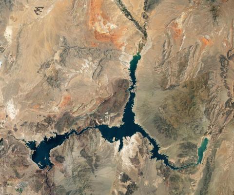
NASA confirmed that water levels in Lake Mead, located in Nevada and Arizona, are at their lowest since April 1937, when the reservoir was being filled for the first time.
As of Monday, Lake Mead, the largest reservoir in the United States, was filled to 27% capacity, according to NASA.
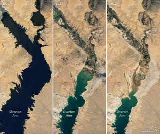
The photos shared by the NASA Earth Observatory, taken in 2000, 2021 and 2022, show Lake Mead appearing to grow less and less full of water, even in the one-year span between 2021 and 2022. The image from 2000 shows swaths of Lake Mead full of water, while the image from 2022 only shows one section, known as Overton Arm, filled.
The lake's water levels have fallen nearly 160 feet since July 2000 and 26 feet since July 2021.
The severity of this loss is underlined by its impact on those who have relied on Lake Mead's water for decades. The images also arrive as states throughout the West experience high levels of drought – with 74% of nine Western states currently reporting some level of drought, and 35% facing extreme levels, according to the U.S. Drought monitor.
"The largest reservoir in the United States supplies water to millions of people across seven states, tribal lands, and northern Mexico," NASA Earth Observatory's news release reads. "It now also provides a stark illustration of climate change and a long-term drought that may be the worst in the U.S. West in 12 centuries."
In recent months, the rapidly receding waters at Lake Mead have revealed human bodies, ghost towns, a crashed B-29 Superfortress and more.
"This is just the tip of the iceberg," Travis Heggie, a former National Park Service official who has studied deaths at Lake Mead Recreation Area, told USA TODAY in May.
The water elevation at Hoover Dam, which formed Lake Mead, is dropping significantly. According to data from the U.S. Bureau of Reclamation, the water elevation of Hoover Dam was almost 1,200 feet in July 2000. As of July 18 this year, it had fallen to about 1,040 feet.
The last time Lake Mead was at maximum capacity, reaching an elevation of about 1,220 feet near the dam, was in 1983 and 1999, NASA notes.
Lake Powell, which sits above Lake Mead in northern Arizona and southern Utah, is also at dangerously low levels. Similar to Lake Mead, Lake Powell is now at 27% capacity, according to NASA.
Earlier this summer, the U.S. Reclamation Commissioner warned surrounding states that the losses on the Colorado River system meant water users would need to make more immediate cuts to protect future supplies and power generation at both Hoover Dam and Glen Canyon Dam, which backs up Lake Powell upstream.
The Bureau of Reclamation will release a set of projections for 2023 in August, which that could trigger even deeper cuts in water usage.